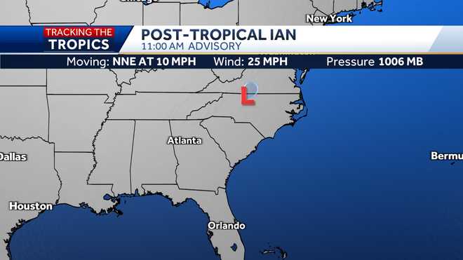
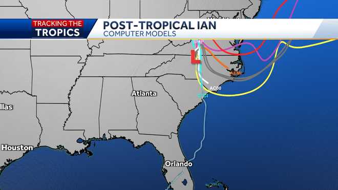
INGRAM. CHELSEA: GOOD MORNING. KIND OF THE MORNING YOU WANT TO SLEEP IN A LITTLE, BECAUSE IT IS JUST SO WET OUTSIDE. WE WILL BE DEALING WITH SHOWERS ON AND OFF THROUGH THE ENTIRE DAY AS WE TRACK THE REMNANTS OF IAN. NOT ONLY THAT, A BIT OF A FALL CHILL SETTLES IN FOR THE NEXT COUPLE DAYS. THERE IS ONE DAY WHERE HIGHS ARE ONLY IN THE 50’S. I WILL SHOW YOU THAT IN THE SEVEN-DAY. SUNSHINE WILL RETURN. SO WE’LL WARMER TEMPERATURES. WE HAVE TO WAIT UNTIL THE MIDDLE OF THE UPCOMING WORK WEEK. HERE IS A LOOK AT SATELLITE AND RADAR. THIS IS ALL THE REMNANTS OF IAN. DEFINITELY CHANGED A LITTLE BIT, BECAUSE NOW WE HAVE FRONTS INVOLVED. IT IS NO LONGER A TROPICAL ENTITY. WE ARE DEALING WITH BASICALLY A NOR’EASTER IN THE MID-ATLANTIC. WE HAVE STEADY ARRAY MOVING ACROSS PORTIONS OF CENTRAL MARYLAND, BUT NOW THEY ARE STARTING TO PULL INTO NORTHERN MARYLAND. STILL BREEZY OUT THERE HERE THAT WILL BE THE CASE THROUGH THE ENTIRE DAY. ON TOP OF THAT, WE HAVE SHOWERS THAT BUILD INTO THE AFTERNOON. TEMPERATURES RIGHT NOW IN THE 50’S. 50 FIVE IN PARKVILLE. 55 — 54 IN PIKESVILLE. 57 IN RAW CALL. — 57 IN ROCK PAUL. — ROCK HALL. EACH AND EVERY HOUR, WE HAVE THE RISK FOR A SHOWER TO DEVELOP. EXPECTING SHOWERS THE AFTERNOON. WINDS FROM THE EAST. WE HAVE THE FLOW OFF THE ATLANTIC. SHOWERS WE WILL DEAL WITH THROUGH THE ENTIRE DAY. THE WINDS ARE EXPECTED TO PICK UP AS WELL. BWI MARSHALL, PRETTY WINDY. WE COULD SEE GUSTS OVER THE 30 MILE-PER-HOUR RANGE. HIGH TIDES, BECAUSE WE HAVE A HIGH TIDE AROUND 9:00, WE WILL BE DEALING WITH A COASTAL FLOODING ADVISORY FOR ANNE ARUNDEL COUNTY AND POINTS ON THE WESTERN SHORE OF THE BAY SOUTH OF BALTIMORE CITY. UP TO A FOOT OF INUNDATION WILL BE POSSIBLE AS A RESULT. FUTURECAST, A BIT OF A BREAK FROM ONGOING RAIN. THEN WE TAP INTO SHOWERS GOING THROUGH THE AFTERNOON, SO WE CANNOT GUARANTEE A DRY HOUR AT ALL. OTHERWISE, IT WILL BE PRETTY WET. SUNDAY, THIS ONSHORE FLOW CRANKS AND MORE MOISTURE. IN THE AFTERNOON, ESPECIALLY THE RAVENS GAME, IS LOOKING VERY WET CARE THAT WILL CONTINUE MONDAY NIGHT INTO MONDAY MORNING. FUTURECAST NUMBERS ANYWHERE FROM ABOUT 1 TO 2 INCHES DEPENDING WHERE YOU LIVE. OVERNIGHT LOWS FALLING INTO THE 50’S TONIGHT. YOUR SEVEN-DAY FORECAST. 57 IS THE HIGH TEMPERATURE.
Remnants of Ian bring showers throughout the weekend in Maryland
The risk for scattered showers continues Saturday as remnants of Ian move through Maryland.While meteorologists are not forecasting major damage in Maryland from the storm system, central Maryland could see 1-2 inches of rain, and 2-5 inches of rain in southern Maryland and the Eastern Shore.Video above: Watch Meteorologist Chelsea Ingram’s forecast|| Radar | Closings/Delays | Weather Advisories | Forecast | Email Alerts | Send us your pics ||Winds are expected to increase Friday night, with gusts 30-40 miles per hour, remaining through Monday.Timeline for MarylandShowers are possible after 3 p.m. Friday and will become heavier after 8 p.m. Heavy rain overnight, tapering by 8 a.m. SaturdayShowers and drizzle continue Saturday into SundaySteady rain may redevelop Sunday afternoonScattered showers linger Monday and TuesdayThe sun finally returns WednesdayThe storm made landfall near Georgetown, South Carolina around 2 p.m. Friday as a Category 1 hurricane. Since then, the National Hurricane Center said Ian has transitioned into an extratropical low.Follow: @ttasselWBAL | @AvaWBAL | @TonyPannWBAL | @ChelseaWeather | @wbaltv11Here’s how to get severe weather alerts from the WBAL-TV app Marylanders travel to help with rescue effortsA volunteer Swiftwater rescue team from the Baltimore region has left Florida and is heading north, but they’re not on their way back to Maryland – they are following Hurricane Ian.The five members from the Baltimore region, deployed with Tidewater Disaster Response, are on the outskirts of Charleston, South Carolina for now.The members have been on the road since Tuesday. They said slept about 12 hours total since departing the DMV area, and are now on their third stop to help people in the wake of Hurricane Ian.Tidewater Disaster Response is an all-volunteer, five-member, Swiftwater rescue team from the Baltimore region. Logistics coordinator, Costa Sardelis, is from Elkridge.The teamed checked in with 11 News when they stopped to fuel up on their way north out of Florida.Sardelis said they are following the storm: “So, right now we’re heading towards Charleston. We started in Fort Myers, obviously.”The work on Florida’s coastal communities was grueling, he said. The five members were deployed, cross-trained in debris removal.”The first obstacle was physically gaining access into Fort Myers, which required our team to stop about every quarter mile, two-mile to clear debris from the roadways,” Sardelis said. “There was a lot of standing water, storm surge. I wouldn’t classify it as true Swiftwater but definitely water with a current. Our first boat launch was officially Thursday morning at 1:05 a.m. and we continued rescue operations until about 5:30. when for safety items, I’d have to call it due to exhaustion for the team. And we got back at it, at around 8 a.m.”The crew took a power nap in between rescues and wellness checks.”Full successful rescues? I believe we had seven total, we had a variety of wellness checks mixed in there as well,” Sardelis said. “We also completed a handful of successful rescues in conjunction with the other teams we were working with who were other non-nonprofit volunteers.”Track the tropics: Hurricane mapsHow you can help hurricane victimsWBAL-TV and Hearst Television affiliates nationwide are partnering with the Red Cross to help people affected by hurricanes. Your donation enables the Red Cross to prepare for, respond to and help people recover from this disaster.CLICK HERE TO DONATE
The risk for scattered showers continues Saturday as remnants of Ian move through Maryland.
While meteorologists are not forecasting major damage in Maryland from the storm system, central Maryland could see 1-2 inches of rain, and 2-5 inches of rain in southern Maryland and the Eastern Shore.
Video above: Watch Meteorologist Chelsea Ingram’s forecast
|| Radar | Closings/Delays | Weather Advisories | Forecast | Email Alerts | Send us your pics ||
Winds are expected to increase Friday night, with gusts 30-40 miles per hour, remaining through Monday.
Timeline for Maryland
- Showers are possible after 3 p.m. Friday and will become heavier after 8 p.m.
- Heavy rain overnight, tapering by 8 a.m. Saturday
- Showers and drizzle continue Saturday into Sunday
- Steady rain may redevelop Sunday afternoon
- Scattered showers linger Monday and Tuesday
- The sun finally returns Wednesday
The storm made landfall near Georgetown, South Carolina around 2 p.m. Friday as a Category 1 hurricane. Since then, the National Hurricane Center said Ian has transitioned into an extratropical low.
Follow: @ttasselWBAL | @AvaWBAL | @TonyPannWBAL | @ChelseaWeather | @wbaltv11
Marylanders travel to help with rescue efforts
A volunteer Swiftwater rescue team from the Baltimore region has left Florida and is heading north, but they’re not on their way back to Maryland – they are following Hurricane Ian.
The five members from the Baltimore region, deployed with Tidewater Disaster Response, are on the outskirts of Charleston, South Carolina for now.
The members have been on the road since Tuesday. They said slept about 12 hours total since departing the DMV area, and are now on their third stop to help people in the wake of Hurricane Ian.
Tidewater Disaster Response is an all-volunteer, five-member, Swiftwater rescue team from the Baltimore region. Logistics coordinator, Costa Sardelis, is from Elkridge.
The teamed checked in with 11 News when they stopped to fuel up on their way north out of Florida.
Sardelis said they are following the storm: “So, right now we’re heading towards Charleston. We started in Fort Myers, obviously.”
The work on Florida’s coastal communities was grueling, he said. The five members were deployed, cross-trained in debris removal.
“The first obstacle was physically gaining access into Fort Myers, which required our team to stop about every quarter mile, two-mile to clear debris from the roadways,” Sardelis said. “There was a lot of standing water, storm surge. I wouldn’t classify it as true Swiftwater but definitely water with a current. Our first boat launch was officially Thursday morning at 1:05 a.m. and we continued rescue operations until about 5:30. when for safety items, I’d have to call it due to exhaustion for the team. And we got back at it, at around 8 a.m.”
The crew took a power nap in between rescues and wellness checks.
“Full successful rescues? I believe we had seven total, we had a variety of wellness checks mixed in there as well,” Sardelis said. “We also completed a handful of successful rescues in conjunction with the other teams we were working with who were other non-nonprofit volunteers.”
Track the tropics: Hurricane maps
How you can help hurricane victims
WBAL-TV and Hearst Television affiliates nationwide are partnering with the Red Cross to help people affected by hurricanes. Your donation enables the Red Cross to prepare for, respond to and help people recover from this disaster.


