

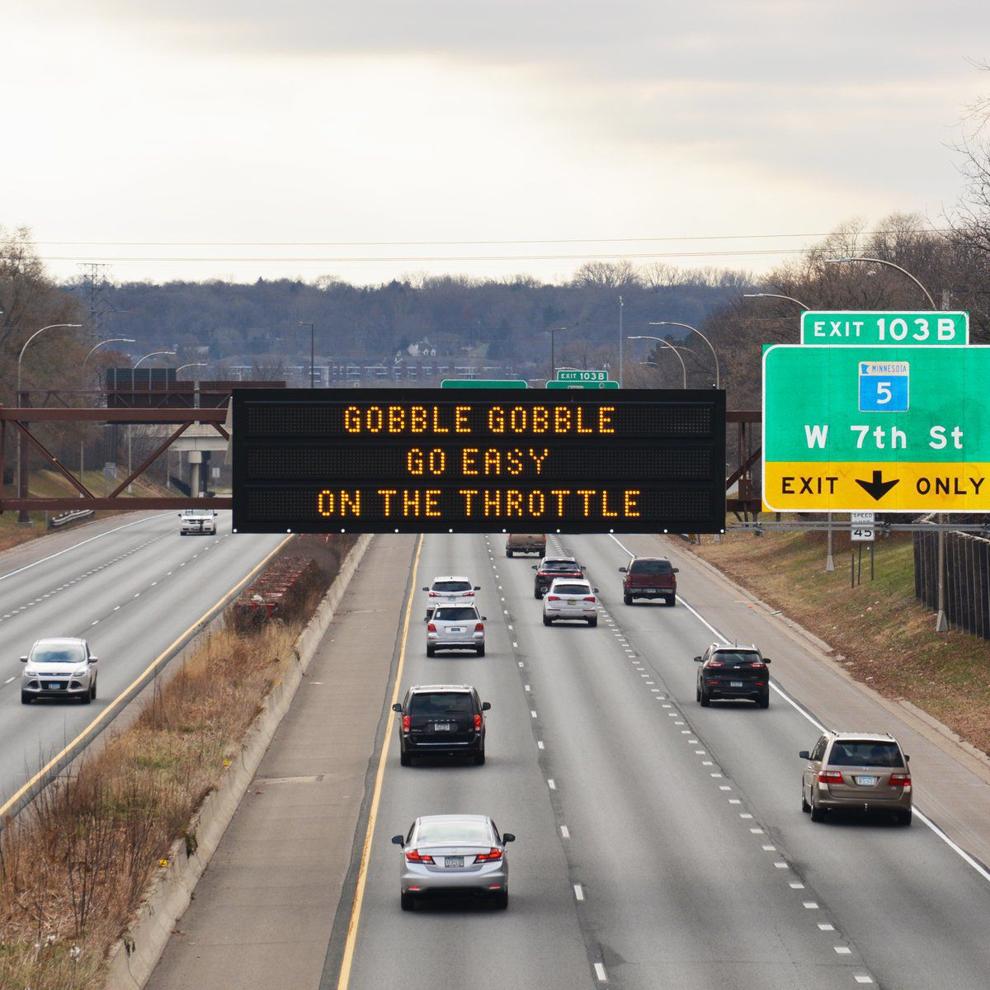
This is Thanksgiving week. A substantial percentage of U.S. trucks will be parked over the Wednesday, November 24 through Sunday, November 28 period. For those in the trucking industry getting a well-deserved break, have fun, enjoy the food, festivities and your families.

For those in the trucking industry who either have to work or choose to work, be careful out there! Families traveling to visit relatives and friends will clog the highways over the next week. This can make any stretch of road more difficult to drive and potentially more dangerous. Add in potentially poor weather conditions and the kick-off of the year-end holiday season can be hazardous to your health.
FreightWaves Classics has featured numerous articles during 2021 about the U.S. Interstate Highway System (IHS) and the National Highway System (NHS) – their history, specific highways, etc. There are nearly 47,000 miles in the IHS, and over 161,000 miles in the NHS (which includes the IHS). Some of these highways (or sections of these highways) are among the best roads in the world. Unfortunately, some are not.
Roads – no matter how well-planned, constructed and maintained – are not perfect, and unfortunately accidents are inevitable. Also, most U.S. highways were not designed for trucks. Some highways are safer than others; however, FreightWaves Classics profiles 10 of the most dangerous highways and routes in the nation for truckers. I have driven (either in an auto or an RV) on each of these roads, and would agree with the list…

I-10 in Arizona
Interstate 10 is the southernmost interstate highway that spans the nation. At 2,460 miles, it is the fourth-longest interstate and runs from Santa Monica, California, to Jacksonville, Florida. Of that total, only 150 miles of I-10 are in Arizona. It runs east from the California line to Phoenix. Truckers have noted that I-10 lacks median barriers and that its traffic volume has increased dramatically over the past 20 years. Most of the highway runs through the desert; this leads drivers to speed, and to become distracted by the scenery (or lack thereof). These and other factors have caused I-10 in Arizona to be tagged as the nation’s most dangerous highway. It averages 85 deaths annually.

I-95 in Connecticut
Interstate 95 runs from Maine to Florida; it is over 1,900 miles long. It is also among the oldest and most heavily traveled interstates in the nation. In Connecticut, I-95 has a dual personality; it is the major trucking route in the Northeast, and is also a primary commuter route between New York, New Haven and beyond. And while the interstate only runs for 88 miles in Connecticut, it is always heavily traveled.
Alaska’s Dalton Highway
The James Dalton Highway is one of the most isolated roads in the United States and the northernmost highway in Alaska. It is 414 miles long, and not really a highway as defined in the Lower 48. (It is a dirt road!) It was built as a supply road for the Trans-Alaska Pipeline and was originally named North Slope Haul Road. Now it also provides access to the three towns along its route and for tours to the Arctic Ocean. It runs from its intersection with the Elliott Highway north of Fairbanks to the Prudhoe Bay oil fields near the town of Deadhorse and the Arctic Ocean.
It winds through a relatively desolate area. Drivers must deal with wildlife, ruts and potholes, and a variety of assorted obstacles (and that’s during the summer months!). In the winter, temperatures along the road drop to subzero. Truckers may face blizzards, avalanches and icy roads.
To help drive the point home that the Dalton Highway can be treacherous, it was the focus of the first episode of the BBC’s World’s Most Dangerous Roads. Truckers that drive the road have given it nicknames like Oil Spill Hill, Beaver Slide and a few others that can’t be printed on this site.
The road includes a 240-mile stretch with no services; no filling stations, restaurants or hotels. At any time of year (but certainly in the winter), drivers must be equipped with food, water, fuel, first aid supplies, appropriate clothing, spare tires, emergency gear, an emergency toolkit and good luck!

US 2 in Montana
U.S. Route 2 (US 2) runs for nearly 2,600 miles across parts of the northern tier of the United States. While US 2 passes through 11 states, the most dangerous part of the highway, according to researchers at the University of Minnesota, is US 2 in Montana. The highway’s highest traffic death rate is in Montana.
The highway runs for 760 miles in Montana, and it is particularly dangerous during the winter months. US 2 runs through many rural areas; it is prone to black ice, blizzards and high winds. Because of the rural countryside and lack of traffic, drivers tend to go faster than they should, which means the highway is even more dangerous for truckers. If there is a traffic accident, response times for first responders averages 80 minutes.

US 550 in Colorado
A spur of U.S. Route 50, US 550 runs from Bernalillo, New Mexico to Montrose, Colorado. The section of US 550 from Silverton to Ouray is known as the “Million Dollar Highway.” It is one of the roads on the Trails of the Ancients Byway, one of the designated New Mexico Scenic Byways.
What became US 550 was originally built in the 1880s to link mining camps in the area with the railroad. The road was rebuilt to be part of the original federal highway system (U.S. routes) in the 1920s. The highway has been rerouted a number of times since then.
The most dangerous section of US 550 is located in southwestern Colorado. The 25-mile section is particularly dangerous for truckers because it has numerous curves as it climbs and descends steep mountains. Moreover, it does not have shoulders and guardrails in some areas.
California’s Route 138
This state highway runs for about 105 miles through California’s Mojave Desert. Route 138 has been called the “Highway of Death,” “blood alley” and “California Death way,” because accidents on the road over a five-year period caused 56 fatalities and 875 injuries. The two-lane road twists and winds through the desert and also has steep grades along its route. In 2006, Caltrans improved the highway, making the lanes wider in places and improving key site lines. However, it is still a dangerous road…

I-285 in Atlanta
The “Perimeter” is a nearly 64-mile interstate highway loop around Atlanta. Interstate 285 links Atlanta-area traffic to three interstate highways – I-20, I-75 and I-85. More than 2 million vehicles travel on I-285 daily. Class 8 trucks are prohibited from the three interstates inside I-285 unless they are making local deliveries; which means they must use I-285 to bypass the city. The Perimeter is also a major commuter highway, so rush hour traffic, interchanges with the interstates and state routes and construction that never seems to end increase the number of accidents on the highway.
On the north side of Atlanta, I-285 intersects I-85 at “Spaghetti Junction.” The roadway increases to 18 lanes, and wrecks happen when motorists get caught in the wrong lane and attempt to cut through traffic. Intersections with I-20 and I-75 are almost as bad.
For those who drive in or around metro Atlanta, you don’t know where an accident will occur on I-285, but you are sure that one will.

I-26 in South Carolina
South Carolina’s most dangerous road is a section of Interstate 26. From its intersection with US 23 and US 11W in Kingsport, Tennessee southeastward to its intersection with US 17 in Charleston, there were 286 recorded accidents and 325 fatalities between 2000 and 2010. The majority of the wrecks happened on stretches of I-26 that did not have guardrails and/or did have steep ditches. Truckers have reported that the most common accidents on this stretch of I-26 include overturned trucks or vehicles and collisions in moving traffic.

US 431 in Alabama
With sections of US 431 dating back to 1930, the highway runs for 556 miles, from Owensboro, Kentucky, to Dothan, Alabama. The highway runs for 98 miles in Alabama between Phoenix City and Dothan. It is considered one of America’s most dangerous roads. Often people will erect small white crosses at accident sites to recognize the deaths of loved ones. There are too many of these white crosses along this roadway, silent witnesses to the many accidents that have occurred.
US 129 in North Carolina
While US 129’s overall length is almost 582 miles, it is an 11-mile section of the highway in North Carolina and Tennessee that is known as the “Tail of the Dragon” and is the most dangerous. On those 11 miles there are 318 curves; they have caused the highway’s reputation as a crash zone. There were over 200 truck crashes on the Tail of the Dragon just between 2010 to 2012. Six of those accidents resulted in deaths. The area around this section of US 129 is in a remote and sparsely populated area, and the highway’s curves attract motorcyclists and sports car drivers. The combination of people wanting to test their skills on the curves and trucks using the route to do their work is not a good one.
