As cities and regions around the world are getting incorporated into the globalisation and urbanisation processes, they simultaneously exhibit characteristics that are more diverse and complex due to the relations of their local and regional bases. It holds for many Indian cities, which are restructuring themselves under the process of urbanisation, but with their unique regional–cultural aspects or dimensions.
In recent years, Indian cities and their neighbourhoods have been constantly changing under the guise of urban development. The rapid growth of a city and its built-up areas lead to the continuous absorption of surrounding villages and agricultural lands. As a result, these surrounding villages, which are known as peri-urban areas, show structural and functional changes over a period of time. An understanding of the links between the city and its peri-urban areas is important in the evolution of urban areas. Urbanisation, only in terms of its growth or planning, is not enough, but imbibing the experiences of these peri-urban areas is equally important to acknowledge the ongoing rural–urban transformation in India.
Such rural–urban transformation has led to many positive changes together with frequent disasters. While events like floods, earthquakes, cyclones, and tsunamis are generally identified as natural events, their impact on human society makes people come together to shape their environments. The capacity of human systems to deal with such events depends on a variety of factors that include the nature of public institutions, ideological positions, quality of human resources, and the available technology within specific social systems at a given point in time. In addition, the geomorphological characteristics of areas affected by such events add to variations in the coping abilities of people across these areas.
However, despite a similar magnitude even within a small area, differentials in the impact of a hazardous phenomenon also vary across groups by way of their locations, in terms of access, and negotiable entitlements in society. Therefore, an understanding of the causes and impacts of such disasters call for an analysis within different sociopolitical systems in terms of a temporal and spatial perspective. And within this context, such disasters simultaneously become “natural” as well as “human.”
Vadodara City: Flooding
Vadodara, formerly known as Baroda, is the third largest city in Gujarat after Ahmedabad and Surat. As per the Census of 2011, Vadodara’s population was almost 18.22 lakh. The city is situated on the banks of Vishwamitri river, in central Gujarat. The Vishwamitri frequently dries up in the summer, leaving only a small stream of water. An important industrial, cultural, and educational hub of western India, the city houses several institutions of national and regional importance while its major industries include petrochemicals, engineering, chemicals, pharmaceuticals, plastics, and information and technology services.1 If one looks at the history of Vadodara city, the period of 1875–1939 was considered as the golden period and an era of progress and achievements in all fields under the enigmatic rule of Maharaja Sayajirao Gaekwad III. It is one of the first planned cities under the town planner and sociologist Patrick Geddes.
History of Floods in Vadodara
Although there have been many floods in the city like the one in 1878 with 1,956 millimetre (mm) of rain or the 1917 floods with 1,753 mm of rain, the most lethal one came in 1927 with about 2,286 mm of rain. In the last week of July 1927, Vadodara witnessed the highest recorded levels of rainfall—about 2,286 mm—as opposed to the normal annual rain of 890 mm. It poured constantly for four days such that the water levels of Vishwamitri river rose high and its water touched the bottom of the Kala Ghoda statue. In folk consciousness, it is known as Ghodapur (floods that touched the horse statue). The flood disrupted essential services such as the railway and power supply and submerged the ground floor of many houses as well as the Shree Sayaji General Hospital. A lot of damage was also sustained by the Sayaji Baug Zoo as the animals drowned and died in their cages.2
Vadodara gets rainfall from the south-west monsoon winds (June–September). The weather is generally cloudy with frequent spells of rainfall. The annual rainfall (between 1981 and 2020) analysis gives the following results as shown in Figure 1 (Shah et al 2021).
Figure 1 shows 10 years (1981, 1983, 1990, 1994, 1996, 1997, 2005, 2006, 2013, and 2019) that recorded more than 1,200 mm rain. Between 2015 and 2020, the rainfall had crossed above 5,000 mm. Less than half of the average annual rain fall (less than 500 mm) was recorded in 1986, 1987, 1999, 2000, and 2002. In 2006, 2013, and 2019, Vadodara had a very high rainfall.
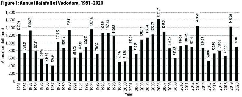
The number of rain days are decreasing with time. The years 2016, 2017, and 2018 also recorded less than half of
the average annual rainfall (less than 500 mm). The year 2019 was an unusual one for rainfall as Vadodara received 2,492.5 mm of precipitation and had broken the highest rainfall record of 1971 (2,160.60 mm).
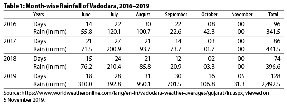
Table 1 shows rainy days and rainfall/precipitation (in mm) from 2016 to 2019.
Ajwa Reservoir and Vishwamitri River
Originating from Pavagadh in the Panchmahal district of Gujarat, the Vishwamitri flows mainly through the west of Vadodara. After the confluence of two other tributaries, namely Dhadhar and Khanpur, into it, Vishwamitri merges into the Gulf of Khambhat. This river system includes the Ajwa lake near Ajwa, and the Dev Dam on the Dhadhar branch. As it flows through Vadodara, the river receives the city’s sewage and effluents from the nearby industries.
Vishwamitri is home to crocodiles, which is one of the endangered reptile species in India, legally protected under Schedule I of the Wild Life (Protection) Act, 1972. Despite heavy pollution load and large human disturbances, the presence of the crocodiles in large numbers indicates the unique ecological significance of this river. However, rapid growth in population, industrialisation, and urbanisation has degraded the river to such an extent that like many urban rivers, the Vishwamitri is now considered as “Gattar Ganga,” which means a drain.
Ajwa Reservoir
This reservoir is an earthen dam built in the early 20th century by the then ruler of Vadodara, Maharaja Sayajirao Gaekwad III. Its main aim was to provide drinking water to its residents. Although the population of Vadodara at that time was a mere 1,00,000, it was the ruler’s vision to build a reservoir five times larger. This reservoir is about five kilometre (km) long and can provide water to roughly 5,00,000 people residing in the eastern parts of the city. It can store water to a height of 213 feet above the sea level. The floor of the reservoir is around 196 feet. The dam is connected to Vishwamitri, and in the event of a flood, the excess water is dispatched to the river. The Ajwa reservoir has 62 gates and a canal of the Sardar Sarovar Dam feeds water into the reservoir. The Pratappura Sarovar or the Pratapsinh Tank also built by Maharaja Sayajirao Gaekwad III was mainly to supply water to the Ajwa reservoir. There are seven gates of which three are connected to Vishwamitri.
Relationship with Vishwamitri River
Over the years, the Vishwamitri river system has suffered due to urbanisation and industrialisation. Despite having multiple dams on the river system, it faces flooding and thus suffers floodplain encroachment and storm-water outfalls. Neglect in maintaining the river system and the release of sewage waters, industrial effluents, and other sources of pollution have led to the deterioration of the river system.
According to a study commissioned by the Amrut Sitaram Pradhan (ASP) Foundation,3
the major causes of the degradation are improper sewage management, increased impervious surface, and deforestation throughout the watershed, encroachment within the floodplain, lack of concern for ecological processes, invasive species, open dumping of solid waste, and lack of sensitivity for historical context in development.
Like many urban rivers, Vishwamitri exhibits symptoms of the “urban stream syndrome,” 4 a condition defined by challenges, such as floodplain encroachment, poor water quality, habitat degradation, increase of tolerant species, and bank erosion (Walsh et al 2005: 706).
Before reaching Vadodara, much of the water from Pavagadh passes through the Ajwa lake; during every monsoon season, the water from the Ajwa dam overflows from the Ajwa lake and makes its way towards Vadodara, destabilising the banks adjacent to the dam and flushing sediments downstream. The situation turns menacing when heavy rainfall in the catchment areas of Ajwa reservoir necessitates the opening of the spillway gates to release water. When the Vishwamitri river overflows, it results in floods in large areas of Vadodara, and the release of water from the Ajwa reservoir causes havoc in the city.
Due to intense sedimentation, the water-storing capacity of Ajwa reservoir has decreased drastically. Land use changes in the upper watershed areas of the Vishwamitri river have altered the hydrologic functions of the watershed as a whole. For example, the conversion of forestland for agriculture in the upper watershed has decreased groundwater recharge, as there are fewer large trees and plants that do not have deep roots in the soil to promote infiltration of rainwater. The heavy seasonal rainfall and reduced forest cover increase erosion along the course of the river above the Ajwa reservoir, leading to sedimentation within it that reduces its capacity for storing run-off and drinking water. In addition, mining operations near Pavagadh, increased urbanisation in the upper watershed, and the high-velocity pulse of water overflowing from Ajwa reservoir during the monsoons contribute to the substandard quality of water and flooding in Vadodara.
As any city expands, there is a loss of agricultural land and land degradation takes place in the villages at the peri-urban areas of urban development. Simultaneously, there is also the inflow of city life that is adopted eagerly by the people of these same peri-urban areas. They are no longer rural but are also not completely urban. They are, however, in the process of becoming urban centres. The proximity of villages to the city core as well as time and space determine the level of the process. Major issues emerging out of this urban transformation are (i) collusion among the local politicians, municipal corporation officials, land mafias, and land developers; (ii) introduction of town planning schemes influenced by the powerful local politicians and bureaucrats and not based on the needs of the area; (iii) intentional delay in the process of non-agriculture permission, encroachment, and illegal construction either on government land or on private land; (iv) residential areas planned only after the village entered into the city limit; (v) unplanned industrial and commercial areas, environmental degradation; (vi) dumping garbage in the river and natural drains; and (vii) poor air and water quality.
The 2019 floods in Vadodara reminds of the urban governance decisions having time and again sanctioned dumping within and the encroachment of river floodplains, resulting in the disappearance of several wetlands and water systems associated with the river. As a result of the destruction of several of these natural sponges and the reduction in the river flood-carrying capacity, the city has become prone to flooding. Floodwaters inundating the low-lying parts of the city have resulted not only in despair for the people living in these areas but also created situations of human–animal conflict, as they endanger the habitat for crocodiles within the river as well as in Sayaji Baug Zoo.
Vadodara has also witnessed major devastating floods of varying intensity in 1941, 1970, 1974, 1976, 1983, 1994, 1996, 2005, and the recent floods of 2019. Frequent occurrence of flooding in Vadodara due to the river has caused untold adversities and problems to the citizens of the city for days that have stretched to a week. The middle and poor classes are the worst-affected by flooding. Small traders and big businesses in low-lying areas also suffer heavy losses due to floodwaters entering in their business premises.
Technical Solutions
Gopal Shah (Shah and Lobo 2021), an eminent town planner based in Vadodara, has suggested the following: looking at the carrying capacity of the Vishwamitri, an additional 150 cubic metre per second (cumec) water is required to be managed so that floods can be averted in Vadodara. A reservoir has been proposed at Kotambi on government land having a mean sea level (MSL) of 45 metres. Unfortunately, the rate of water percolation in the soil is very low due to the black cotton soil. The water table in Kotambi area is around 30 to 40 metres deep. The land, which is around 212 acres, is barren and owned by the government. If the reservoir is made 10 metres deeper at Kotambi, it could store and provide water throughout the year to Vadodara (37.18 metres MSL), which could be around five million litres per day (MLD) through the process of gravity. Additional water from the reservoir can be bypassed to the Mini river through a canal section measuring 15 metres × 4 metres deep at 2.5 cumec velocity. The water from the reservoir, which is at 45 metre MSL, can be easily diverted to Mini river, which is at 33.2 metre MSL. The benefits of this solution according to Shah are: (i) flooding in Vadodara can be easily averted; (ii) bypass channel will be able to take water more than 150 cumec to the Mini river; (iii) Vadodara will get 5 MLD of water throughout the year as also a new water source; and (iv) Vadodara will not develop and grow towards the proposed channel in the next 50 years.
Kushang Shah (Shah and Lobo 2021), a hydrologist, suggests urban storm water management application by interlinking the city lakes. During the rule of the Gaekwads, the lakes of the old city had a proper network of storm drains that facilitated the rainwater to drain into these lakes which acted as a channel as most of the lakes were interconnected. Unfortunately, these lake interlinks have now been encroached upon or filled with sewage and garbage. Because of unplanned urbanisation, much of the landscape around the lakes have been encroached upon and covered with impervious surfaces. Hence, the sponges of the urban areas of the past era have turned into hazards now. There are 24 lakes scattered within the city. Among them, 21 major ones face issues of overflowing in the monsoons, causing serious inundation in the nearby areas. Restoring interlinkages between these lakes will provide relief from constant floods. In this way, the lakes can act as storage reservoirs, which would diminish the effects of flooding and waterlogging, thereby reducing the chances of lakes drying up during summer.
Urban Flooding in India
India has suffered urban flooding for decades but sufficient attention was not given to specific efforts to deal with it. In the past, any strategy on flood-related disaster management largely focused on riverine floods affecting large rural areas. Urban flooding is significantly different from rural floods. Urbanisation itself leads to developing catchments in the event of high-intensity rainfall. Hence, a higher run-off takes place leading to flood peaks from 1.8 to 8 times and flood volumes up to six times. Consequently, flooding occurs quickly due to faster flow times, sometimes in a matter of minutes.
Urban areas are usually centres of economic activities with vital infrastructure that need to be protected at all times—day or night. In most cities, damage to vital infrastructure has a bearing at the local and wider levels. These areas are also densely populated and people living in such vulnerable areas, both rich and poor, suffer because of flooding. This has always resulted in the loss of life, damage to property, and disruptions in transport and power, thus bringing life to a grinding halt, causing untold misery, and hardships. Even the secondary effects of possible epidemics and exposure to infection takes a further toll in terms of loss of livelihood, human suffering, and, in extreme cases, even loss of life. Therefore, the management of urban flooding has to be accorded top priority.
The increasing trend of urban flooding is a universal phenomenon and poses a great challenge to urban planners the world over. Problems associated with urban floods range from relatively localised incidents to major incidents, resulting in cities being inundated from a few hours to several days. Therefore, the impact can also be widespread, including temporary relocation of people, damage to civic amenities, deterioration of water quality, and the risk of epidemics (Ge 2019).
There has been an increasing trend of urban flood disasters in India over the past several years whereby major cities have been severely affected. The most notable among these are Hyderabad in 2000, Ahmedabad in 2001, Delhi in 2002 and 2003, Chennai in 2004, Mumbai in 2005, Surat in 2006, Kolkata in 2007, Jamshedpur in 2008, Delhi in 2009, Guwahati and Delhi in 2010, and Vadodara in 2014 and 2019. Devastating floods occurred in Kerala in 2018 and 2020 and Chennai in 2015, causing untold damages.
Back in the 2000s, Delhi’s Swaminarayan Akshardham temple complex and the Commonwealth Games Village (CWG) were built right on the Yamuna’s floodplain. The secondary runway of the Chennai International Airport was also built right over the Adyar river. Most of the airport was constructed on the riverine floodplains, leading to massive flooding during the 2015 Chennai floods. Even recent developments, such as Andhra Pradesh’s Amaravati Sustainable Capital City Development Project, had major areas proposed to be built on the floodplains of the Krishna river. Patna received focused attention precisely on account of it being the capital of Bihar. While Patna has received disproportionate attention, many other cities and towns in Bihar went under water and stayed in that condition for several days (Singh and Upmanyu 2019).
In any city, low-lying regions—small drains, railway lines, roads, and highways where squatter settlements spring up—are the areas that are most prone to flooding. Built without permission from the local authorities and with makeshift materials, many people lose their residence in the recurring floods, and this loss never gets accounted for. This is typically the case in Delhi’s Yamuna–Pushta area, the same floodplain region where Swaminarayan Akshardham and the CWG have been built. The slum areas surrounding them are flooded almost every year. After intense rainfall, the suburban and low-lying areas of Mumbai near the Mithi river remain waterlogged without services, appropriate shelter, potable water, or food. This area, which includes one of the largest slums in the world—Dharavi, has about 70% slum and pavement dwellers (Singh and Upmanyu 2019).
One does not realise yet that the vulnerability of the poor to the changing climate is profound in the cities. Floodwater circulates untreated solid waste matter around squatter settlements that leads to outbreaks of malaria, dengue, and diarrhoea for a much longer time than the monsoon season. A lack of discernment in development adds to the vulnerability of the poor. During the 2015 Chennai floods, some of the worst-affected areas were slum resettlement tenements constructed by the government on floodplains or lake catchment areas at Semmancheri, Perumbakkam, and Ezhil Nagar. These areas faced severe flooding, causing some deaths and remained inhabitable for many days afterwards (Ge 2019).
While the above reasons are at a macro level and cannot be laid at the doors of the state or city administration, cities around country must take their fair share of the blame (Jha 2019). These relate both to urban planning and urban governance. On the planning side, cities are guilty of undermining at least four vital elements—neglecting storm water drains, filling up water-carrying small drains, reducing and concreting open space, and piling up both built and demographic density. On the governance side, cities are guilty of ignoring the unauthorised construction, failing to prevent encroachments, especially on waterbodies, and overlooking the maintenance and upkeep of the city’s overall drainage infrastructure.
Storm water drains, generally built at the edge of roads, are designed to drain excess water from impermeable surfaces such as footpaths, streets, and roofs and empty this water into a larger water system. Most cities in India do not have storm water drains; some have them in select localities and still others have poor interconnection between the drains. Above all, almost all the urban storm water drains over time get clogged with mud and material whose utility rate, as a consequence, gets reduced to near zero.
Another recent practice in cities is to cover the water drains by laying concrete drain pipes and building roads above them. Mounting city traffic congestion is sought to be relieved by this dodgy shortcut, but it seriously hampers the capacity of drains as well as their maintenance. Furthermore, open spaces are unnecessarily made impermeable in the city for the water to seep in. All this happens, primarily, on account of demographic pressure that generates the need for more living space, and also, the mounting traffic snarls create demand for more space. More open spaces of the cities thereby get converted into built-up spaces.
Conclusions
In conclusion, one can easily say that overburdened drainage and frenzied and unregulated construction with no regard for the natural topography and hydro-geomorphology all make urban floods a man-made disaster in many cities and towns in India. Based on these current practices in urban areas, many cities like Delhi, Chennai, Amaravati, Mumbai, Ahmedabad, Patna, and Vadodara face frequent flooding. Of course, one cannot ignore the wider climate changes contributing to the floods in India and elsewhere.
Notes
1 https://irtpms.in/site/about-vadodara/.
2 https://historyofvadodara.in/the-floods/.
3 https://seas.umich.edu/masters-projects/vishwamitri-river-and-its-reign-2017, retrieved on 5 November 2019.
4 The urban stream syndrome describes the consistently observed ecological degradation of streams draining to urban land, including flashier flows, elevated concentrations of nutrients and contaminants, altered channel morphology and stability, and reduced biodiversity, all of which are noticeable in the Vishwamitri River (Walsh et al 2005).
References
Ge, Krupa (2019): Rivers Remember: Chennairains and the Shocking Truth of a Manmade Flood, Chennai: Context.
Jha, Ramanath (2019): “Indian Cities and Floods,” Observer Research Foundation, 22 October, viewed on 16 September 2020, https://www.orfonline.org/expert-speak/indian-cities-and-floods-56915/.
Shah, Gopal (2021): “Water Discharge Management from Ajwa Reservoir,” Integrated Urban Flood Management: A Case Study of Vadodara Floods 2019, Shah Jayesh and Lancy Lobo (eds), Vadodara: Centre for Culture and Development, pp 130–35.
Shah, Jayesh and Lancy Lobo (eds) (2021): Integrated Urban Flood Management: A Case Study of Vadodara Floods 2019, Vadodara: Centre for Culture and Development.
Shah, N V, Y S Patel and P D Bhangaonkar (2021): “Assessing Impact of Climate Change on Rainfall Patterns of Vadodara District, Gujarat, India,” Journal of Physics: Conference Series 1714 012046, doi:10.1088/1742-6596/1714/1/012046.
Shah, Kushang (2021): “Urban Storm Water Management Application: Interlinking of City Lakes,” Integrated Urban Flood Management: A Case Study of Vadodara Floods 2019, Shah Jayesh and Lancy Lobo (eds), Vadodara: Centre for Culture and Development, pp 136–67.
Singh, Mitashi and Varnika Upmanyu (2019): “Urban Flooding: The Case of Drowning Cities and Rising Vulnerability,” Down to Earth, 11 October, viewed on 5 November 2019, https://www.downtoearth.org.in/blog/natural-disasters/urban-flooding-the-case-of-drowning-cities-and-rising-vulnerability-67203.
Walsh, C J, A H Roy, J W Feminella, P D Cottingham, P M Groffman and R P Morgan II (2005): “The Urban Stream Syndrome: Current Knowledge and the Search for a Cure the Urban Stream Syndrome,” Journal of the North American Benthological Society, Vol 24, No 3, pp 706–23, viewed on 5 November 2019, https://doi.org/10.1899/04-028.1.